How to Use a Survey Arrow: A Beginner’s Guide for Field Surveyors
Introduction to Survey Arrows
Survey arrows, also known as chaining pins or surveying pins, are fundamental tools in the field of land surveying that have been used for centuries to mark temporary points and measure distances accurately. These simple yet essential instruments serve as critical markers during the surveying process, helping surveyors establish precise measurements and maintain chain alignment during distance calculations. Understanding how to properly use survey arrows is crucial for anyone entering the field of surveying, whether you’re a student, apprentice, or professional looking to refine your techniques.
The art of surveying requires precision, attention to detail, and a thorough understanding of the tools at your disposal. Survey arrow represent one of the most basic yet indispensable tools in a surveyor’s toolkit. Their primary function extends beyond simple marking; they serve as reference points that enable surveyors to maintain accuracy over long distances, establish temporary benchmarks, and create a systematic approach to field measurements that can be replicated and verified by other professionals.
In modern surveying practice, while advanced GPS technology and electronic distance measuring devices have revolutionized the field, survey arrows remain relevant and necessary. They provide a tangible, reliable backup method that doesn’t rely on battery power or satellite signals, making them particularly valuable in remote locations or challenging environmental conditions. The tactile nature of these tools also helps surveyors develop a deeper understanding of measurement principles and spatial relationships that pure digital methods might not provide.
Understanding the Components of a Survey Arrow
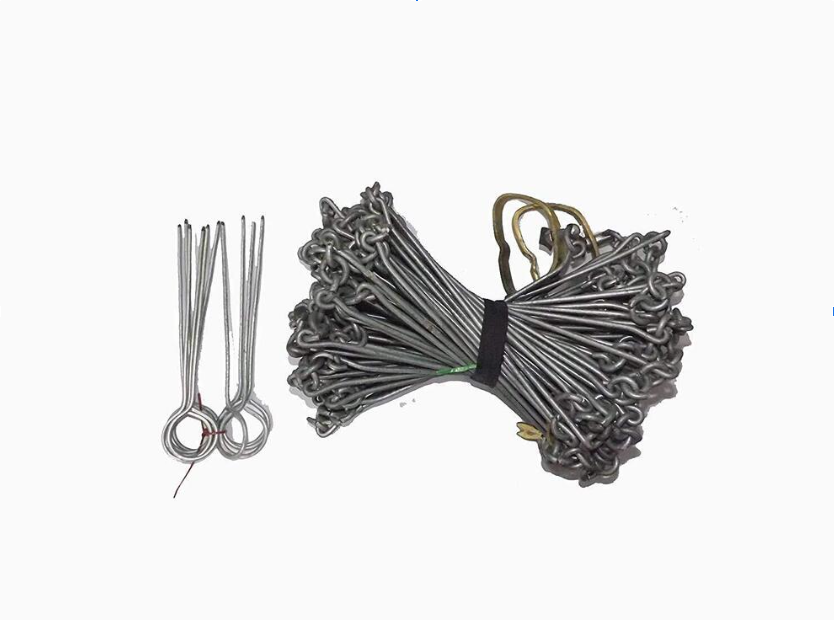
A typical survey arrow consists of several key components that work together to provide accurate marking and measurement capabilities. The pointed end, crafted from hardened steel, is designed to penetrate various soil types and ground conditions while maintaining its sharp edge through repeated use. This pointed tip is engineered with a specific angle that balances penetration ability with holding power, ensuring that the arrow remains securely in place even in challenging weather conditions or soft soils.
The shaft of a survey arrow is typically constructed from high-grade steel that offers the perfect combination of flexibility and strength. This material choice prevents the arrow from breaking under stress while allowing for slight bending when encountering rocks or other underground obstacles. The shaft’s length is standardized to provide optimal visibility above ground while ensuring adequate penetration depth for stability. Professional-grade survey arrows often feature a slightly tapered shaft design that reduces drag during insertion while maximizing holding power once placed.
At the head of each survey arrow, you’ll find a bright-colored flag or marker, usually made from durable vinyl or cloth material. These markers serve multiple purposes beyond simple visibility. The color coding system allows surveyors to differentiate between various types of measurements, property boundaries, or survey points at a glance. The flag’s size and shape are carefully designed to remain visible from significant distances while withstanding wind, rain, and other environmental factors that could compromise their effectiveness during extended field work.
The connection between the flag and the shaft typically involves a secure attachment system that prevents accidental separation while allowing for easy replacement when flags become worn or damaged. Some survey arrows feature removable flags that can be customized with specific markings, numbers, or codes that correspond to detailed survey notes and measurements. This customization capability makes survey arrows particularly valuable for complex projects involving multiple reference points or collaborative work between different surveying teams.
Types of Survey Arrows and Their Applications
Standard survey arrows represent the most commonly used type in general surveying applications. These arrows typically measure between eleven to fourteen inches in length and feature bright orange or red flags that provide excellent visibility in most environmental conditions. Standard arrows are ideal for property boundary surveys, construction layout work, and general distance measurements where temporary marking is required. Their versatility makes them suitable for both urban and rural surveying projects, adapting well to various soil conditions and weather patterns.
Heavy-duty survey arrows are designed for challenging conditions where standard arrows might prove insufficient. These robust versions feature thicker shafts, reinforced points, and enhanced flag attachment systems that can withstand harsh weather conditions, rocky soil, and heavy foot traffic. Professional surveyors often choose heavy-duty arrows for long-term projects, areas with significant public access, or locations where environmental factors might compromise standard equipment. The additional durability comes with increased weight and cost, but the investment proves worthwhile in demanding field conditions.
Specialized survey arrows include variations designed for specific applications or environmental conditions. Magnetic arrows incorporate powerful magnets that allow attachment to metal surfaces, bridges, or construction equipment when ground penetration isn’t possible. Weighted arrows feature additional mass in the shaft or head that helps them penetrate hard-packed soil or frozen ground more effectively. Some specialized versions include adjustable flags, reflective materials for low-light conditions, or waterproof markers for maritime or wetland surveying applications.
Color-coded arrow systems represent another important category where different colored flags indicate specific types of measurements or survey points. Professional surveying teams often develop standardized color schemes where red arrows mark property corners, blue arrows indicate utility locations, yellow arrows mark temporary reference points, and green arrows designate environmental or conservation boundaries. This systematic approach reduces confusion during complex projects and helps maintain accuracy when multiple surveyors work on the same site over extended periods.
Essential Equipment and Tools Needed
Beyond the survey arrows themselves, successful field surveying requires a comprehensive toolkit that supports accurate measurement and documentation. A reliable measuring chain or tape represents the primary distance-measuring tool that works in conjunction with survey arrows. Modern surveying often utilizes fiberglass or steel tapes that resist stretching and provide consistent measurements across various temperature and humidity conditions. The choice between different tape materials depends on the specific surveying requirements, environmental conditions, and accuracy needs of each project.
A sturdy hammer or mallet specifically designed for driving survey arrows becomes essential when working with hard or compacted soils. Professional survey hammers feature weighted heads that provide sufficient force for penetration while including features like magnetic nail holders, comfortable grips, and balanced designs that reduce fatigue during extended use. Some surveyors prefer rubber mallets for delicate work or situations where noise reduction is important, while others opt for steel-headed hammers when maximum penetration force is required.
Field notebooks and documentation tools ensure that all measurements and observations are properly recorded for future reference and legal documentation. Weatherproof notebooks with gridded pages facilitate accurate sketching and note-taking in challenging conditions. Many modern surveyors complement traditional paper records with digital devices like tablets or smartphones that offer GPS integration, photography capabilities, and instant data backup to cloud storage systems. The combination of traditional and digital documentation provides redundancy and ensures that critical survey data isn’t lost due to equipment failure or environmental damage.
Additional support equipment includes items like plumb bobs for ensuring vertical alignment, levels for establishing horizontal references, and range poles for maintaining sight lines over long distances. A comprehensive first aid kit addresses safety concerns in remote locations, while communication devices like two-way radios or satellite communicators ensure team coordination and emergency response capabilities. Weather protection gear, including rain suits, sun protection, and cold weather clothing, enables surveyors to maintain accuracy and safety across diverse environmental conditions.
See also: Strategic Business Financial Planning 3533025745
Setting Up Your Survey Arrow Properly
Proper survey arrow placement begins with careful site assessment and planning that takes into account both immediate measurement needs and potential long-term implications. Before driving any arrows, surveyors must evaluate soil conditions, underground utility locations, property boundaries, and environmental factors that might affect arrow placement or visibility. This preliminary assessment prevents damage to buried utilities, ensures compliance with local regulations, and establishes a foundation for accurate measurements throughout the project duration.
The physical process of setting survey arrows requires attention to both technique and positioning that ensures optimal performance and longevity. When driving arrows into the ground, surveyors should maintain vertical alignment to prevent angular errors that could compromise measurement accuracy. The penetration depth should provide adequate stability while leaving sufficient above-ground height for visibility and flag attachment. In soft soils, arrows may require deeper penetration to prevent shifting, while rocky conditions might limit depth and require alternative securing methods.
Positioning considerations extend beyond individual arrow placement to encompass the overall survey strategy and measurement sequence. Survey arrows should be placed at strategic intervals that facilitate accurate chain measurements while providing clear sight lines between points. The spacing between arrows depends on terrain conditions, measurement requirements, and the specific surveying method being employed. Professional surveyors often establish a systematic approach to arrow placement that can be easily understood and replicated by other team members or future survey crews.
Environmental factors play a crucial role in survey arrow setup and must be considered throughout the planning and implementation process. Wind conditions affect flag visibility and may require adjusted positioning or alternative marking methods. Rain and moisture can soften soil and affect arrow stability, potentially requiring additional securing measures or modified placement techniques. Temperature extremes can impact both equipment performance and soil conditions, necessitating adaptive approaches that maintain measurement accuracy regardless of weather conditions.
Basic Measurement Techniques
Chain measurement using survey arrows follows established procedures that have been refined through generations of surveying practice. The process begins with establishing a baseline between two fixed points, with survey arrows marking intermediate positions that ensure chain alignment and measurement accuracy. The surveyor holds one end of the chain at the starting point while an assistant advances to the full chain length, using survey arrows to mark each measurement increment. This systematic approach prevents cumulative errors and provides multiple reference points for verification and quality control.
The proper technique for chain measurement requires coordination between team members and adherence to established protocols that minimize error introduction. The chain holder maintains tension and alignment while the advancing surveyor ensures that each measurement maintains the correct direction and distance. Survey arrows are driven at each chain length, creating a permanent record of the measurement process that can be verified through reverse measurements or independent confirmation by other surveying teams.
Slope corrections represent a critical aspect of chain measurement that must be addressed when working on uneven terrain. Survey arrows help establish reference points that allow surveyors to calculate horizontal distances from slope measurements, ensuring that final measurements reflect true horizontal distances rather than slope distances. This correction process becomes particularly important in hilly or mountainous terrain where slope angles significantly affect measurement accuracy and legal boundary determinations.
Measurement verification through multiple techniques enhances accuracy and provides confidence in survey results. Professional surveyors often employ redundant measurement methods, using survey arrows as common reference points between different measurement techniques. Electronic distance measurement devices, GPS systems, and traditional chain measurement can all utilize the same survey arrow positions, allowing direct comparison of results and identification of any discrepancies that might indicate errors or equipment problems.
Advanced Surveying Methods with Survey Arrows
Triangulation surveys utilize survey arrows as critical reference points in complex measurement networks that provide high accuracy over large areas. This advanced technique involves establishing a series of triangles with carefully measured sides and angles, using survey arrows to mark triangle vertices and intermediate points. The mathematical relationships between these triangular networks allow surveyors to determine positions and distances with exceptional precision, making triangulation particularly valuable for large-scale mapping projects and boundary surveys covering extensive areas.
Traverse surveying incorporates survey arrows into systematic measurement sequences that follow property boundaries or establish control networks across diverse terrain. Each survey arrow marks a traverse station where both distance and angular measurements are recorded, creating a connected series of points that can be mathematically analyzed for accuracy and closure. Advanced traverse techniques require careful attention to angular measurement, distance control, and error distribution that ensures final survey results meet professional accuracy standards and legal requirements.
Radiation surveying methods employ survey arrows as central reference points from which multiple measurements extend to locate features, boundaries, or construction elements. This technique proves particularly valuable in construction surveying where building corners, utility locations, and site features must be precisely positioned relative to established reference points. Survey arrows provide stable, visible reference points that remain accessible throughout the construction process, facilitating ongoing layout work and quality control measurements.
Topographic surveying utilizes survey arrows to establish elevation benchmarks and horizontal control points that support detailed terrain mapping and contouring work. Advanced topographic techniques combine traditional measurement methods with modern electronic surveying equipment, using survey arrows as common reference points that ensure consistency between different measurement approaches. The integration of survey arrows with GPS technology and electronic levels provides surveyors with flexible, reliable reference systems that adapt to various terrain conditions and project requirements.
Common Mistakes and How to Avoid Them
Improper arrow placement represents one of the most frequent errors that can compromise survey accuracy and create long-term problems for project completion. Many beginning surveyors fail to adequately assess soil conditions before driving arrows, resulting in unstable reference points that shift over time or become dislodged by environmental factors. Avoiding this mistake requires thorough site evaluation, proper driving techniques, and regular monitoring of arrow stability throughout the survey process. Professional surveyors develop systematic approaches to arrow placement that consider both immediate needs and long-term stability requirements.
Chain alignment errors often occur when surveyors fail to maintain proper direction and tension during measurement sequences. Survey arrows should create straight lines between measurement points, but inadequate attention to alignment can introduce angular errors that accumulate over long distances. Preventing alignment errors requires careful attention to sight lines, proper chain handling techniques, and regular verification measurements that confirm directional accuracy. Modern surveyors often supplement traditional alignment methods with electronic theodolites or GPS systems that provide additional verification of measurement direction and accuracy.
Documentation failures represent another common category of mistakes that can invalidate survey results or create confusion for future work. Many surveyors fail to adequately record survey arrow positions, identification numbers, or measurement relationships in their field notes. This oversight can make it impossible to reconstruct survey measurements or verify results through independent confirmation. Comprehensive documentation practices should include detailed sketches, measurement records, and photographic documentation that captures survey arrow positions and surrounding environmental conditions.
Equipment maintenance neglect can lead to measurement errors and field work delays that compromise project timelines and accuracy. Survey arrows require regular inspection for damage, wear, or stability issues that might affect their performance. Chain and tape equipment must be calibrated and maintained according to manufacturer specifications to ensure measurement accuracy. Professional surveyors establish routine maintenance schedules that address equipment condition, calibration requirements, and replacement needs before problems affect field work quality or safety.
Maintenance and Care of Your Survey Arrow
Proper cleaning and storage procedures significantly extend survey arrow lifespan and maintain their effectiveness in field applications. After each use, arrows should be thoroughly cleaned to remove soil, vegetation, and other debris that could promote corrosion or affect performance. Steel surfaces require particular attention to prevent rust formation, especially after use in wet conditions or coastal environments where salt exposure accelerates corrosion processes. Professional-grade cleaning solutions and protective coatings help maintain arrow condition and ensure reliable performance throughout their service life.
Flag replacement and maintenance represent routine tasks that ensure survey arrows remain visible and functional throughout extended projects. Flags naturally deteriorate due to weather exposure, UV radiation, and physical wear that can compromise their visibility and identification capabilities. Establishing regular inspection schedules allows surveyors to identify and replace worn flags before they affect field work efficiency or measurement accuracy. Many professional surveying companies maintain flag replacement supplies and develop standardized procedures that ensure consistent arrow appearance and identification systems.
Point sharpening and repair become necessary as survey arrows encounter rocks, hard soil, and repeated use that gradually dulls their penetrating edges. Professional arrow maintenance includes regular point inspection and sharpening using appropriate tools and techniques that restore optimal penetration performance. Severely damaged arrows may require professional repair or replacement to maintain safety and effectiveness standards. Some surveying operations maintain arrow repair capabilities in-house, while others utilize specialized services that provide comprehensive maintenance and refurbishment programs.
Inventory management and tracking systems help surveying operations maintain adequate arrow supplies and monitor equipment condition across multiple projects and team members. Professional operations often implement numbering systems, tracking databases, and regular inventory audits that ensure arrow availability and identify maintenance needs before they affect field work. Digital tracking systems can integrate with project management software to provide comprehensive equipment oversight and maintenance scheduling that optimizes arrow performance and operational efficiency.
Safety Considerations in the Field
Personal protective equipment represents the foundation of safe survey arrow use and should be considered mandatory for all field surveying operations. Safety glasses protect eyes from flying debris when driving arrows or working around vegetation and construction activities. Steel-toed boots provide foot protection from dropped equipment and arrow points while offering stable footing on uneven terrain. High-visibility clothing ensures surveyor safety around traffic and construction equipment, while weather-appropriate protective gear maintains comfort and safety across diverse environmental conditions.
Underground utility awareness requires systematic evaluation and clearance procedures before driving survey arrows into any unknown soil conditions. Professional surveyors must contact local utility location services and obtain clearance verification before beginning field work that involves ground penetration. Even shallow arrow placement can damage buried utilities, creating safety hazards and expensive repair costs that far exceed the inconvenience of proper clearance procedures. Emergency response planning should address potential utility strikes and include immediate notification procedures for utility companies and emergency services.
Environmental hazards assessment encompasses evaluation of terrain conditions, weather factors, and biological risks that could affect surveyor safety during field work. Steep slopes, unstable soil, and adverse weather conditions require modified work procedures and additional safety precautions that may affect survey arrow placement and measurement techniques. Wildlife concerns, poisonous plants, and insect hazards represent additional factors that require awareness and appropriate protective measures. Professional surveyors develop site-specific safety plans that address identified hazards and establish emergency response procedures for various risk scenarios.
Team communication and coordination protocols ensure that all survey crew members understand safety requirements, emergency procedures, and their specific roles in maintaining safe work environments. Clear communication channels, regular safety briefings, and established hand signals or radio procedures help coordinate safe and efficient field operations. Emergency contact information, first aid capabilities, and evacuation procedures should be established and understood by all team members before beginning field work in remote or challenging locations.
Professional Tips for Accurate Measurements
Temperature considerations significantly affect both equipment performance and measurement accuracy, requiring professional surveyors to understand and compensate for thermal effects on chains, tapes, and arrow materials. Steel measuring equipment expands with increasing temperature and contracts as temperatures decrease, introducing systematic errors that can accumulate over long measurement sequences. Professional practice includes temperature monitoring, correction calculations, and equipment calibration procedures that account for thermal effects and maintain measurement accuracy across varying environmental conditions.
Measurement redundancy techniques provide verification capabilities and error detection that enhance survey reliability and professional credibility. Experienced surveyors routinely employ multiple measurement methods, independent confirmation procedures, and systematic error checking that identifies and corrects mistakes before they affect project results. Survey arrows facilitate these redundancy techniques by providing stable reference points that support multiple measurement approaches and verification procedures. The additional time invested in redundant measurements typically proves worthwhile by preventing expensive errors and rework.
Field note organization and documentation standards reflect professional surveying practice and provide essential support for measurement verification, legal documentation, and future reference needs. Comprehensive field notes should include detailed measurements, sketches, environmental observations, and reference information that allows complete reconstruction of survey procedures and results. Professional surveyors often develop standardized notation systems, sketching techniques, and documentation formats that ensure consistency and completeness across different projects and team members.
Quality control procedures integrated throughout the survey process help identify and correct errors before they compromise project results or require expensive rework. Professional quality control includes regular equipment calibration, measurement verification, and systematic error checking that maintains high accuracy standards. Survey arrows support quality control efforts by providing stable reference points for verification measurements and independent confirmation of survey results. Established quality control protocols should address measurement accuracy, documentation completeness, and safety compliance throughout all phases of survey work.
Troubleshooting Common Issues
Arrow stability problems often arise from inadequate soil assessment or improper driving techniques that fail to provide secure anchoring in challenging ground conditions. Solutions may include deeper penetration, alternative arrow types, or supplementary anchoring methods that enhance stability and prevent movement. Professional troubleshooting approaches systematically evaluate soil conditions, environmental factors, and arrow placement techniques to identify and address stability issues. In extreme cases, alternative reference methods like concrete monuments or permanent markers may be necessary to ensure measurement reliability.
Chain measurement discrepancies can result from equipment problems, alignment errors, or systematic mistakes that accumulate over long measurement sequences. Troubleshooting procedures should include equipment inspection, calibration verification, and independent measurement confirmation using alternative methods or equipment. Survey arrows provide reference points that facilitate error identification and correction by enabling partial remeasurement of specific segments rather than complete survey repetition. Professional troubleshooting approaches systematically isolate and address measurement discrepancies while maintaining project schedules and accuracy requirements.
Visibility and identification problems with survey arrows can compromise field work efficiency and measurement accuracy, particularly in areas with dense vegetation or challenging environmental conditions. Solutions may include alternative flag colors, enhanced markers, or supplementary identification methods that improve arrow visibility and recognition. Professional approaches often include standardized marking systems, photographic documentation, and GPS coordinates that provide multiple identification methods and ensure arrow location even when visual markers are compromised.
Environmental damage to survey arrows from weather, vandalism, or accidental disturbance requires prompt identification and replacement to maintain survey continuity and accuracy. Professional response procedures should include regular arrow inspection, replacement protocols, and documentation methods that track arrow condition and replacement history. Backup reference methods and redundant measurement systems help minimize project disruption when arrow damage occurs, while systematic monitoring helps identify and address recurring damage patterns that might require modified placement or protection strategies.
Certified Material Testing Products (Certified MTP) is a leading supplier of construction materials testing equipment and laboratory supplies in the United States. They offer a comprehensive range of products for testing concrete, asphalt, aggregate, soil, and cement, catering to both field and laboratory applications But no matter whether they are prefered or not, the whole idea behind these tools is similar: getting a polished, shiny, and permanent effect. New to stucco or a seasoned pro, investing in good tools and learning the nuances of their use is what will get you started perfecting your craft.
Conclusion
Survey arrows represent fundamental tools in modern surveying practice that continue to provide essential capabilities despite advances in electronic and satellite-based measurement technologies. Their simplicity, reliability, and cost-effectiveness make them indispensable for surveyors working across diverse environments and project types. Mastering proper survey arrow techniques provides beginning surveyors with foundational skills that enhance understanding of measurement principles while supporting practical field work capabilities that remain relevant throughout professional careers.
The techniques and principles outlined in this guide provide comprehensive coverage of survey arrow applications, from basic measurement procedures to advanced surveying methods that utilize arrows as components of complex measurement networks. Professional competence requires understanding not only proper techniques but also safety requirements, maintenance procedures, and quality control methods that ensure reliable results and safe working conditions. The integration of traditional survey arrow methods with modern technology creates powerful surveying capabilities that combine proven reliability with enhanced accuracy and efficiency.
Continued professional development in survey arrow techniques should include regular practice, equipment familiarization, and exposure to diverse field conditions that challenge and refine technical skills. Professional surveying organizations, educational institutions, and industry publications provide ongoing resources for skill development and technical updates that keep surveyors current with evolving best practices and regulatory requirements. The investment in mastering survey arrow techniques provides lasting benefits that enhance surveying capabilities and professional credibility throughout diverse career opportunities.
Future developments in surveying technology will undoubtedly introduce new tools and methods, but the fundamental principles demonstrated through survey arrow use will remain relevant and valuable. Understanding these principles provides surveying professionals with adaptable skills that transfer to new technologies while maintaining appreciation for proven methods that continue to provide reliable results. The combination of traditional techniques with modern innovations creates comprehensive surveying capabilities that serve diverse client needs and project requirements across various industries and applications.
Frequently Asked Questions
What is the standard length for survey arrows and why does it matter?
Survey arrows typically measure between 11 to 14 inches in length, with 12 inches being the most common standard. This length provides an optimal balance between adequate ground penetration for stability and sufficient above-ground visibility for identification and flag attachment. The standardized length ensures consistency across different surveying projects and allows for predictable performance in various soil conditions. Professional surveyors may choose longer arrows for soft soils that require deeper penetration or shorter arrows for rocky conditions where deep penetration isn’t possible.
How deep should I drive survey arrows into the ground?
The ideal penetration depth for survey arrows depends on soil conditions, environmental factors, and project duration. Generally, arrows should be driven deep enough to provide stable anchoring while leaving 3 to 4 inches above ground for visibility and flag attachment. In soft or sandy soils, deeper penetration may be necessary to prevent movement, while rocky conditions may limit penetration depth. Professional practice involves assessing soil conditions and adjusting penetration depth accordingly, sometimes requiring alternative anchoring methods in challenging conditions.
Can survey arrows be reused, and how many times?
High-quality survey arrows can typically be reused many times with proper care and maintenance. The lifespan depends on soil conditions, frequency of use, and maintenance practices. Professional-grade steel arrows may last for hundreds of uses when properly maintained, while lower-quality arrows may wear out more quickly. Regular inspection for point damage, shaft bending, and flag condition helps determine when arrows need repair or replacement. Professional surveying operations often implement tracking systems to monitor arrow condition and optimize replacement schedules.
What’s the difference between different colored flags on survey arrows?
Flag colors on survey arrows typically follow standardized coding systems that help surveyors quickly identify different types of measurements or reference points. Common color conventions include red for property corners, blue for utility markers, yellow for temporary reference points, and green for environmental boundaries. However, color coding systems may vary between different surveying companies or regional practices. Professional surveyors should establish clear color coding protocols for each project and document these systems in field notes to prevent confusion.
How do I maintain survey arrows in wet or coastal environments?
Survey arrows used in wet or coastal environments require enhanced maintenance procedures to prevent corrosion and extend service life. After each use, arrows should be thoroughly cleaned and dried to remove salt, moisture, and debris. Protective coatings or rust inhibitors can help prevent corrosion, while regular inspection identifies early signs of deterioration. Storage in dry conditions between uses prevents moisture accumulation, while prompt replacement of damaged components maintains arrow effectiveness. Professional operations in coastal areas often maintain larger arrow inventories to account for accelerated wear and replacement needs.
What should I do if I encounter underground utilities while placing survey arrows?
If underground utilities are encountered during survey arrow placement, work should stop immediately and the situation should be assessed by qualified professionals. Contact local utility location services to verify utility locations and obtain proper clearance before continuing work. In areas with known utility congestion, alternative survey methods like surface monuments or offset reference points may be more appropriate than ground-penetrating arrows. Professional surveying practice requires utility clearance verification before any ground-penetrating activities, preventing damage and ensuring worker safety.
How accurate are measurements using survey arrows compared to GPS or electronic methods?
Survey arrow measurements can achieve high accuracy when proper techniques are employed, often matching or exceeding GPS accuracy in appropriate conditions. Traditional chain measurements with properly placed survey arrows can achieve accuracies within a few hundredths of a foot over reasonable distances. However, GPS and electronic distance measurement devices offer advantages in speed, automation, and challenging environmental conditions. Professional surveying often combines multiple measurement methods, using survey arrows to provide physical reference points that support and verify electronic measurements.
What’s the best way to remove survey arrows without damaging them?
Proper survey arrow removal requires careful technique to prevent damage and ensure reusability. Use appropriate extraction tools like arrow pullers or pliers designed for the purpose, applying steady upward force while rotating the arrow to break soil adhesion. Avoid using excessive force or leverage that could bend or break the arrow shaft. In hard or frozen soil, some soil loosening around the arrow may be necessary before extraction. Clean arrows immediately after removal to prevent soil from hardening on the shaft, making future use more difficult.
How do weather conditions affect survey arrow performance and accuracy?
Weather conditions significantly impact both survey arrow performance and measurement accuracy. Rain can soften soil and affect arrow stability, while also making chains and tapes slippery and difficult to handle. Cold weather can make soil hard and difficult to penetrate, while also affecting metal expansion in measuring equipment. Wind affects flag visibility and can make measurement control more challenging. Professional surveyors adjust techniques based on weather conditions and may postpone work during extreme conditions that compromise accuracy or safety.For more Any Business Card, check out this guide from NFC Business Card Temperature corrections for measuring equipment become particularly important during extreme weather conditions.